
Alright, let's chat about orographic lifting, a cool concept in meteorology that's all about how mountains can affect the weather. Imagine you're a fluffy cloud, just floating along in the sky, minding your own business. Now, picture a big, tall mountain range right in your path. What do you do? You can't go through it, right? So, you go over it. This is where orographic lifting starts to get interesting.
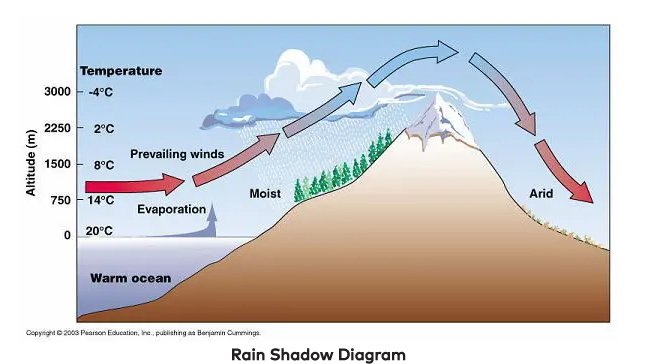
As you, the cloud, start to rise over the mountain, the air around you begins to cool down. This is because, in general, the higher you go, the cooler it gets. It's like when you hike up a tall hill and notice it's chillier at the top than at the bottom. Now, as the air cools, something neat happens: the water vapor in the cloud starts to condense. This is because cooler air can't hold as much moisture as warmer air.
Think of it like your bathroom mirror fogging up during a hot shower. The steam from the shower is like the water vapor in the cloud. When it hits the cooler surface of the mirror, it turns back into tiny water droplets, making the mirror all foggy. In the cloud, as the water vapor condenses, it forms tiny water droplets or ice crystals, depending on how cold it is. This is how clouds get bigger and start to look all fluffy and full.
Now, if there's enough moisture and the cooling is sufficient, these droplets or ice crystals start to combine and grow. When they get too heavy to float in the air, they fall as precipitation – that could be rain, snow, sleet, or hail, depending on the temperature. So, in a way, mountains can create their own weather, which is pretty awesome when you think about it.
This is why you often see rain or snow on one side of a mountain range but not the other. The side where the air climbs up the mountain and cools is called the windward side. This is usually where you get all the action – clouds forming, rain falling, maybe even a thunderstorm brewing. It's like a big, natural cloud-making machine.
On the other side of the mountain, the leeward side, it's a different story. Here, the air descends and warms up. Remember, warm air can hold more moisture, so as the air comes down the mountain, it dries out. This is why the leeward side of a mountain range is often drier and has less rain or snow. It's like the mountain squeezed out all the moisture from the air on the windward side, leaving the leeward side high and dry.
This whole process can lead to some pretty interesting weather patterns. For example, in the Pacific Northwest of the United States, the Olympic and Cascade mountain ranges are famous for their orographic effects. The windward sides of these mountains get a lot of rain, creating lush, green forests. But just a short drive away, on the leeward side, you can find dry, almost desert-like conditions. It's like two different worlds, all because of orographic lifting.
Another cool thing about orographic lifting is how it can create microclimates – small areas with climate conditions that differ from the surrounding areas. This can be great for things like farming, where certain crops might do better in these unique conditions. Winemakers, for example, love these microclimates because they can produce grapes with distinct flavors that you can't get anywhere else.
So, next time you're near a mountain range and notice that one side is rainy and green while the other is dry and brown, you'll know it's all thanks to orographic lifting. It's like the mountains are playing their own little game with the weather, creating different scenes on each side. And that's the story of how mountains can make their own weather – pretty neat, huh?
Share:
Reflection and Refraction
Why It's Important to View an Eclipse